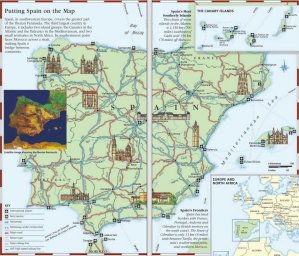
Spain on the Map
Spain, in southwestern Europe, covers the greater part of the Iberian Peninsula. The third largest country in Europe, it includes two island groups: the Canaries in the Atlantic and the Balearics in the Mediterranean, and two small territories in North Africa. Its southernmost point faces Morocco across a strait, making Spain a bridge between continents.
Spain’s Most Southerly Islands
This chain of seven islands in the Atlantic is 1,150 km (700 miles) southwest of Cádiz and 150 km (70 miles) off Morocco.
Spain’s Frontiers
Spain has land borders with France, Portugal, Andorra and Gibraltar (a British territory on the south coast). The Strait of Gibraltar is only 13 km (8 miles) wide between Tarifa, the peninsula’s southernmost point, and northern Morocco.
Satellite image showing the Iberian Peninsula
EUROPE AND NORTH AFRICA
THE CANARY ISLANDS
KEY
International airport
Ferry service
Motorway
Motorway under construction
Major road
Minor road
Main railway line
AVE high-speed railway line
